Stormwater Floodplain Simulation Model
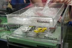
EES owns a tabletop model that simulates the effect that different landscapes have on runoff and the potential for flooding. When it rains on “wetlands,” sponges provide lots of capacity for the landscape to absorb water. The same amount of rain on a “parking lot” causes the river to overflow onto the floodplain and may wash monopoly houses downstream—unless they were constructed with proper anchoring techniques. Of course, the shopping center construction project should have included stormwater management, and the model can also demonstrate the use of a retention pond. Unfortunately, the pond may not hold enough water when consecutive storms (remember all the rain before the 1972 Agnes flood?) cause the already-full retention pond to overflow and flood out a monopoly house neighborhood. We can also use clay to elevate houses, build levees, construct dams, or implement other flood protection strategies.
EES uses this model with students as a fun way to demonstrate the impact of land use changes on downstream flow and then do hands-on experiments with flood protection techniques. Students collect river level data and can later see plots of what happened. The model is also used with adults to illustrate floodplain management concepts—sometimes drawing a floodplain map right on the model.
EES purchased this tabletop model for use throughout Chemung, Schuyler, and Steuben Counties and is seeking volunteers to expand its use for flood education. Please contact us to schedule a train-the-trainer session or to invite us to bring it to your organization.


